
What is a quality hiking region?
A quality hiking region guarantees a perfect hiking experience. Whether a day tour with friends or family, a complete hiking holiday without changing accommodation or a multi-day tour with a lot of luggage: the quality criteria “Wanderbares Deutschland” meet the highest demands in terms of trail infrastructure, hosts, service and tourist information. The criteria for the quality region “Wanderbares Deutschland” are transparent. They enable the objective evaluation of the services offered by a region. The categories define the various aspects of an attractive hiking region. By dealing with the quality criteria behind them, each region can analyse its potential and expand quality across the board. This process requires the cooperation of different actors and strengthens sustainable regional development. For the hiker, an offer is created that is optimally tailored to his or her needs and which he or she can immediately recognise with the help of the “Wanderbares Deutschland” logo. For anyone who has ever been on the road in a quality region, the logo “Qualitätsregion Wanderbares Deutschland” is a “must” when choosing a holiday region.
Further information can be obtained from the German Hiking Association
1.1 Hiking trail network (networking to the inside)
All important starting points and destinations within the region are connected to the network of hiking trails. The hiking trail network is connected and contains all marked hiking trails.
1.2 Hiking trail network (outward networking)
All important destinations outside the region – up to a distance of 5 kilometres – are connected to the network of hiking trails.
1.3 Hiking trail network: coverage of the region
The hiking trail network covers at least 75% of the entire hiking region.
1.4 Hiking trail network: Hiking-friendly trail format
The net route network fulfils the following limit values for the route format:
– Composite pavement: max. 30 % of the road network
– On a busy road: max. 5 % of the road network
– max. 300 metres in one piece (only outside built-up areas)
– Next to a busy road: max. 10 % of the road network
– max. 3,000 meters in one piece
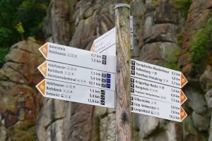
1.5 Uniform route and signage concept
The entire network of hiking trails is signposted according to a uniform and consistent system of paths, markings and signposts.
1.6 Networking with signposts
The hiking trail network is signposted at the most important junctions of marked hiking trails by signposts with at least one clear indication of direction (destinations + distance) per hiking direction. Which nodes are signposted with signposts is set out in a well-formulated concept. In total, at least 50% of the nodes are signposted.
1.7 Hiking-friendly marking
All routes of the hiking trail network are marked according to the rules for quality hiking trails.
1.8 Starting points Quality region: coverage Region
From the Quality Region starting points, all destinations in the region can be reached within a maximum distance of 6 kilometres.
1.9 Starting points Quality region: Equipment
All starting points quality region for hiking trails are equipped with sufficient information for hikers.
The Quality Region starting points are indicated by a clear sign on the through roads or at railway stations/bus stops.
1.10. Starting Points Quality Region: Connection to Gastronomy
For at least 80% of the starting points in the quality region, an inn can be reached within a hike on the network of paths of 6 kilometres or at intervals of one kilometre (with a sign).
1.11. Starting points hiking trails: equipment
Further starting points for hikers are connected to the network of hiking trails and equipped with signposts.
1.12. Quality tours
There are sufficient quality tours in the region (half-day round tours with a minimum length of 5 kilometres) that meet the region’s own quality criteria:
– Natural subsoil: at least 35 %.
– poorly accessible substrate: max. 5 %
– Composite pavement (asphalt, tar pavement, composite stones): max. 20%.
– on a busy road max. 300 meters in one piece
– on average at least 1 landscape change per 2 km (or attractive natural landscape of at least 2 km)
replaces 1 bill of exchange)
– on average at least 1 natural or cultural attraction per 2km
– on average at least 1 cross-linking node per 2 km
– Quality tours begin at a starting point quality region.
1.13. Predicate hiking trail
In the hiking region there is at least 1 Prädikatswanderweg, which is longer than 20 kilometres.

2.1. Offer
The following accommodation categories must be available in the hiking region:
– Hotels
– pensions
– private rooms
– holiday flat
– Group accommodation/youth hostel
– Campsite or camper site
From an area of 500 sq km at least 2 tenders per farm
2.2 Distribution in the area
In the distance of max. 15 kilometers (approach) from a starting point quality region there are at least 2 accommodation offers.
Compliance rate: 80 % of starting points
2.3 Quality hosts Wanderbares Deutschland
In the hiking region there are on average at least 2 quality hosts Wanderbares Deutschland per 100 km2 (0.02 per 1 km2), minimum number: 5 quality hosts
2.4 Hiking competence Host: Referral
The Hiking Region shall ensure that all hosts in the region are informed of a competent Hiking Advice Centre/Person and are provided with material for labelling at the reception desk.
2.5 Hiking Competence Host: Newsletter Hiking
All hosts are regularly informed by a newsletter about new developments in hiking, changes in the hiking offer of the region and changes in the network of hiking trails.
Regularly = at least 2 x a year
2.6 Wandering Competence Host: advanced training
For hosts, a training course on hiking is offered twice a year within the hiking region.
In the hiking region there are offers on various themes or on special types of hikes.
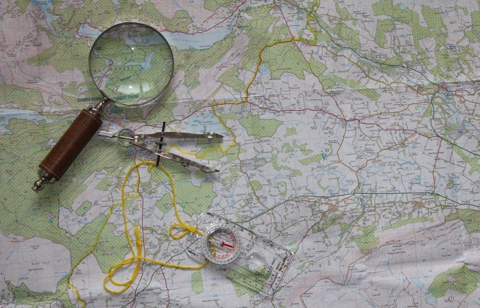
3.2 Hiking map
The entire hiking region is displayed in one or more current hiking maps.
3.3 Hiking brochure
A special hiking brochure describes the region and gives suggestions for hikes.
3.4 Image brochure
In the image brochure of the region at least one double page is dedicated exclusively to the topic of hiking.
3.5 Hiking website
On the homepage the region presents itself as a hiking region:
– On the homepage the topic of hiking is recognizable at first glance.
– There is a special page dedicated to the theme of hiking with a presentation of the network of trails.
– individual tour tips
3.6 Interactive hiking map
An up-to-date interactive hiking map for the entire region with the following characteristics is integrated into the homepage:
– Representation of the entire hiking trail network
– Description of (circular) hiking tours with description
– Selection according to starting points and target groups possible
– Download functions for the selected hiking tour
3.7 Mobility
10 percent of the starting points Quality Region can be reached daily by public transport during the season (April to October).
3.8 Hiking equipment
Within the hiking region there is at least 1 service point for the purchase, rental or repair of hiking equipment. Maximum distance: 25 kilometres.
3.9 Guided hikes
The hiking region offers regularly guided hikes on specific themes. The offer is to be published.
25% of the offer is carried out by certified hiking guides or nature and landscape guides.
It is possible to book hiking guides.
3.10. Hiking packages
The hiking region regularly offers special hiking packages for guests from April to October.

There is sufficient tourist information available in the region. The maximum distance to a tourist information office which is also open on Saturday mornings is 25 kilometres from all starting points in the Quality Region.
4.2 Location
The Tourist-Information(s) are centrally located and easily accessible.
4.3 Hiking competent employees
During the opening hours at least 1 staff member is available, who can advise hikers competently.
4.4 Presence of the hiking theme
At the Tourist Information, the theme of hiking can be recognised at first glance from the outside and inside.
4.5 Hiking display
In the Tourist Information there is a separate section on hiking, which is comprehensively stocked with the most important brochures and maps. The hiking section is recognisable at first glance.
4.6 Current information
In the Tourist-Information you can find current information about hiking at any time.
4.7. sale of information material
The most important hiking maps are sold at the Tourist Information.
4.8 Telephone availability
Outside the opening hours of the Tourist Information, a staff member is available to answer (or forward) questions from walkers/guests.

A framework agreement will be concluded between all partners in the field of hiking to promote and support hiking in the region.
5.2 Agreement on supervision of hiking trails & hiking trail signage
A written agreement or contract is concluded between the partners in the hiking sector to regulate the responsibilities for the management of the hiking trails and the hiking trail signage.
5.3 Nature conservation and sustainability
The hiking region ensures that the network of hiking trails and the tourist marketing of the quality region do not break the principle of sustainability. Conservation concerns as well as the safeguarding of path maintenance and marking guarantees are to be guaranteed over the entire period of use of the label.
5.4 Regulation of road closures
The handling of closures of hiking trails is regulated.
5.5 Rescue service regulations
The care and rescue of injured hikers is regulated.
5.6 Digital route management
The hiking trail network and the signposts are managed digitally.
5.7 Hiking contact persons
In the hiking region there is one or two central contact persons for the hiking themes “Service & Host” and “Path Network & Signage”.